Shop now. New deals everyday!
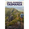
Trail Running Tasmania takes readers, runners, and explorers to every corner of Tasmania on an epic trail running adventure. Run the Overland Track, reach the quartzite summit of Frenchmans Cap, be immersed in the extreme wilderness of takayna / Tarkine, catch a glimpse of a Tasmanian devil, and...
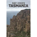
Day Hikes Tasmania takes readers, hikers, and explorers to every corner of Tasmania on an epic bushwalking adventure. Scramble to the top of Hartz Peak, walk along clifftops and beaches to the edge of the world, be immersed in the extreme wilderness of takayna/Tarkine, catch a glimpse of a...
South East Queensland boasts a wide variety of stunning landscapes to explore by day and by night. This guidebook will assist you to plan your overnight adventures in unique locations spanning the sandy islands and blue lakes of Gheebulum Coonungai (Moreton Island), the lush rainforests of...
Artists, poets, writers, naturalists and bushwalkers have all found inspiration amid the distinctive blue haze and hidden beauty of the majestic Blue Mountains. Discover amazing landforms of towering sandstone cliffs; plummeting waterfalls; vegetation communities from open eucalypt forests to...
A trip into Australiau2019s heart and the Top End is an adventure dream for most Australians! Burnt-orange landscapes; stark white ghost gums; iconic rock domes; glowing-red sunsets; night diamonds in unpolluted skies; plummeting waterfalls; rain-drenched wetlands; emerald-green monsoon forests;...
Where to Mountain Bike in South East Queensland (6th Edition) is a compendium of detailed topographic maps on recreational trails suitable for riding your mountain bike , thoroughly covering South East Queensland and a slice of Northern NSW. What's new in the Sixth Edition? 35 new trail...
Family Bushwalks in South East Queensland is a colourful, detailed guidebook packed with hundreds of shorter, easier and more accessible family-friendly bushwalks throughout South East Queensland. The First Edition sold out its print run of 2,500 copies during 2016, making the book a local...
Kosciuszko National Park is all about contrasts. It is a vast area where all facets of the environment go hand-in-hand, and one cannot exist without the other. Turn these pages to explore Australiau2019s highest peaks and deepest gorges where warm summer days can give way to wintry storms and snow...
Explore the best hikes and walking trails that southern NSW and the ACT have to offer with this detailed bushwalking guidebook. Detailed walk descriptions will lead you through 30 national parks and reserves from Sydney to the Victorian border. The guide covers day walks rated from easy to hard,...
The Brisbane Valley and Kilkivan to Kingaroy Rail Trail Guide is a 40-page A4 publication. It contains: detailed maps of the entire Brisbane Valley Rail Trail and Kilkivan to Kingaroy Rail Trails the Link Route between them detailed street maps of the 20 towns along the route 17 detailed maps of...
Family Rides in South East Queensland is a guidebook of detailed maps on bike paths suitable for recreational cycling in South East Queensland . Why are the maps in this book better than the free maps available? Because the authors are cyclists with families! They wanted something better and more...
High Peaks of the Australian Alps: A Guide to the Bushwalks by Robert Rankin Walk featured: Mount Kosciuszko Mount Townsend Mount Jagungal Mount Bogong Bogong High Plains Mount Feathertop Mount Hotham Mount Howitt Mount Speculation Mount Razorback The Crosscut Saw
Tasmania Wilderness Walks: A Guide to the Bushwalks (with an included bonus item) by Robert Rankin is a bushwalker's guide to the spectacular and remote mountainous regions of Tasmania that lie in the southern and western regions of the island state. The book contains maps , descriptions ,...
Trail Running SEQ takes readers, runners, and explorers all over South East Queensland on an epic trail running adventure. Tackle the mountainous Scenic Rim Trail, run along the breathtaking coastline from Rainbow Beach to Noosa, encounter Lamington spiny crayfish as you traverse the Border Track,...
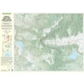
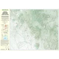
This topographic map covers the north section of the Mackay Highlands Great Walk from Eungella to Crediton Hall and beyond.
This topographic map covers the Mackay Highlands Great Walk from south of Crediton Hall to Denham Range and to Moonlight Dam where the walk ends.
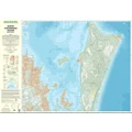
This topographic map of the north of North Stradbroke Island covers from Point Lookout in the north to adjacent to Lamb Island in the south. Several southern Moreton Bay islands are also covered in this map.
Topographic map of the Conondale Range Great Walk showing camp sites and trail.
Topo map of the Glasshouse Mountains in South East Queensland. Includes 9 of the famous mountains: Mt Coochin Mt Ngungun Mt Beerwah Mt Coonowrin Mt Tibrogargan Mt Tibberoowuccum Mt Cooee Mt Tunbubudla Mt Beerburrum
Topographic map of the Maleny-Mapleton Plateau showing the Great Walk of the Sunshine Coast Hinterland. Map prepared by World Wide Maps from the latest QTopo Queensland Government topographic data.